AR for HeritageTogether - The Lost Heritage of Gwynedd in 3D
This project included various contributions to the larger HeritageTogether AHRC project: a) the creation of a web standards-based, non-browser specific Augmented Reality application for the in-situ recreation of standing-stone shrine sites and dolmen, located in North Wales, and b) the web-based 3D model gallery, employing X3DOM and displaying models of said sites, created via photogrammetry.
Collaborators (in various publications)
Bangor University, Manchester Metropolitan University, Aberystwyth University, Gwynedd Archaeological Trust
Related Publications
H. C. Miles, A. T. Wilson, F. Labrosse, B. Tiddeman, S. Griffiths, B. Edwards, P. D. Ritsos, J. W. Mearman, K. Möller, R. Karl, and J. C. Roberts, “Alternative Representations of 3D-Reconstructed Heritage Data,” ACM Journal on Computing and Cultural Heritage (JOCCH), vol. 9, no. 1, pp. 4:1–4:18, Nov. 2015.
By collecting images of heritage assets from members of the public and processing them to create 3D-reconstructed models, the HeritageTogether project has accomplished the digital recording of nearly 80 sites across Wales, UK. A large amount of data has been collected and produced in the form of photographs, 3D models, maps, condition reports, and more. Here we discuss some of the different methods used to realize the potential of this data in different formats and for different purposes. The data are explored in both virtual and tangible settings, and—with the use of a touch table—a combination of both. We examine some alternative representations of this community-produced heritage data for educational, research, and public engagement applications.
[Abstract]
[Details]
[PDF]
[doi:10.1145/2795233]
J. C. Roberts, J. W. Mearman, P. D. Ritsos, H. C. Miles, A. T. Wilson, D. Perkins, J. R. Jackson, B. Tiddeman, F. Labrosse, B. Edwards, and R. Karl, “Immersive Analytics and Deep Maps – the Next Big Thing for Cultural Heritage & Archaeology,” in Visualization for Digital Humanities Workshop, IEEE Conference on Visualization (VIS), Baltimore, MD, USA, 2016.
Archaeologists and cultural heritage experts explore complex multifaceted data that is often highly interconnected. We argue for new ways to interact with this data. Such data analysis provides a ‘grand challenge’ for computer science and heritage researchers, it is big Data, multi-dimensional, multi-typed, contains uncertain information, and the questions posed by researchers are often ill-defined (where it is difficult to guarantee an answer). We present two visions (Immersive Analytics, and Deep Mapping) as solutions to allow both expert users and the general public to interact and explore heritage data. We use pre-historic data as a case study, and discuss key technologies that need to develop further, to help accomplish these two visions.
[Abstract]
[Details]
[PDF]
P. D. Ritsos, A. T. Wilson, H. C. Miles, L. F. Williams, B. Tiddeman, F. Labrosse, S. Griffiths, B. Edwards, K. Möller, R. Karl, and J. C. Roberts, “Community-driven Generation of 3D and Augmented Web Content for Archaeology,” in Eurographics Workshop on Graphics and Cultural Heritage (EGGCH) - Short Papers and Posters, Darmstadt, Germany, 2014, pp. 25–28.
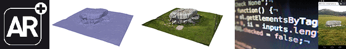
Heritage sites (such as prehistoric burial cairns and standing stones) are prolific in Europe; although there is a wish to scan each of these sites, it would be time-consuming to achieve. Citizen science approaches enable us to involve the public to perform a metric survey by capturing images. In this paper, discussing work-in progress, we present our automatic process that takes the user’s uploaded photographs, converts them into 3D models and displays them in two presentation platforms – in a web gallery application, using X3D/X3DOM, and in mobile augmented reality, using awe.js
[Abstract]
[Details]
[PDF]
[doi:10.2312/gch.20141321]