LUCST: A novel toolkit for Land Use Land Cover change assessment in the SWAT+ model to support flood management decisions - (09/2020 - 06/2023, KESS + WDNA)
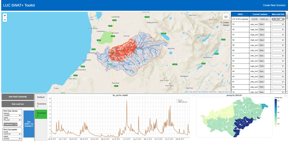
Land Use Land Cover (LULC) change is widely recognised as one of the most important factors impacting river basin hydrology. It is therefore imperative that the hydrological impacts of various LULC changes are considered for effective flood management strategies and future infrastructure decisions within a catchment. LULC changes in a catchment are typically modelled by the Soil and Water assessment Tool (SWAT) through alterations to the input files that define the properties of these HRUs. However, to our knowledge at least, the process of making such changes to the SWAT input files is often cumbersome and non-intuitive. This affects the usability of SWAT as a decision support tool amongst a wider pool of applied users (e.g., engineering teams in environmental regulatory agencies and local authorities).
In this study, we address this issue by developing a user-friendly toolkit that:
- allows the end user to specify, through a Graphical User Interface (GUI), various types of LULC changes at multiple locations within their study catchment,
- runs the SWAT+ model (the latest version of SWAT) with the specified LULC changes, and
- enables interactive visualisation of the different SWAT+ output variables to quantify the hydrological impacts of these scenarios.
Importantly, our toolkit does not require the end user to have any operational knowledge of the SWAT+ model to use it as a decision support tool.
The work is done in collaboration with the School of Natural Sciences and Gwynedd Council’s consultancy arm Ymgynghoriaeth Gwynedd Consultancy (YGC), and was funded by YGC and Knowledge Economy Skills Scholarships (KESS 2), a pan-Wales higher level skills initiative led by Bangor University on behalf of the HE sector in Wales. It is part funded by the Welsh Government’s European Social Fund (ESF) convergence programme for West Wales and the Valleys.
In February 2022 AI extensions to the project received funding from the Wales Data Nation Accelerator, as a Sprint Project.
Publicity
Our work on LUCST has appeared in the North Wales Chronicle.
Related Publications
A. M. F. Rigby, P. W. S. Butcher, P. D. Ritsos, and S. D. Patil, “LUCST: A novel toolkit for Land Use Land Cover change assessment in SWAT+ to support flood management decisions,” Environmental Modelling & Software, vol. 156, no. 105469, Aug. 2022.
Land Use Land Cover (LULC) change is widely recognised as one of the most important factors impacting the hydrological response of river basins. SWAT +, the latest version of the Soil and Water Assessment Tool, has been used extensively to assess the hydrological impacts of LULC change. However, the process of making and assessing such changes in SWAT+ is often cumbersome and non-intuitive, thereby reducing its usability amongst a wider pool of applied users. We address this issue by developing a user-friendly toolkit, Land Use Change SWAT+ Toolkit (LUCST), that will: (1) allow the end-user to define various LULC change scenarios in their study catchment, (2) run the SWAT+ model with the specified LULC changes, and (3) enable interactive visualisation of the different SWAT+ output variables. A good System Usability Score (79.8) and positive feedback from end-users promises the potential for adopting LUCST in future LULC change studies.
[Abstract]
[Details]
[PDF]
[doi:10.1016/j.envsoft.2022.105469]
A. M. F. Rigby, P. W. S. Butcher, S. D. Patil, and P. D. Ritsos, “Using AI and big data to optimise land management decisions for reducing river flood risk,” in Data Transformation: Wales Data Nations Accelerator, Cardiff, UK, 2022.
Local authorities across Wales are increasingly seeking natural approaches to river flood management, especially the role of land management decisions in reducing peak flows. Physics-based hydrological models, which simulate river flood response to storm events, can provide multi-scenario assessment of land-use changes on floods. However, they require prior calibration of parameters using measured streamflow data, which is not available for many rivers. We investigate how AI and big data can be used to implement hydrological models in river basins with no streamflow data.
[Abstract]
[Details]
A. Rigby, S. Patil, and P. D. Ritsos, “A novel toolkit to streamline Land Use Land Cover change assessment in the SWAT+ model to enhance flood management and infrastructure decisions,” in EGU General Assembly 2021, online event, 2021.
Land Use Land Cover (LULC) change is widely recognised as one of the most important factors impacting river basin hydrology. It is therefore imperative that the hydrological impacts of various LULC changes are considered for effective flood management strategies and future infrastructure decisions within a catchment. The Soil and Water assessment Tool (SWAT) has been used extensively to assess the hydrological impacts of LULC change. Areas with assumed homogeneous hydrologic properties, based on their LULC, soil type and slope, make up the basic computational units of SWAT known as the Hydrologic Response Units (HRUs). LULC changes in a catchment are typically modelled by SWAT through alterations to the input files that define the properties of these HRUs. However, to our knowledge at least, the process of making such changes to the SWAT input files is often cumbersome and non-intuitive. This affects the useability of SWAT as a decision support tool amongst a wider pool of applied users (e.g., engineering teams in environmental regulatory agencies and local authorities). In this study, we seek to address this issue by developing a user-friendly toolkit that will: (1) allow the end user to specify, through a Graphical User Interface (GUI), various types of LULC changes at multiple locations within their study catchment, (2) run the SWAT+ model (the latest version of SWAT) with the specified LULC changes, and (3) enable interactive visualisation of the different SWAT+ output variables to quantify the hydrological impacts of these scenarios. Importantly, our toolkit does not require the end user to have any operational knowledge of the SWAT+ model to use it as a decision support tool. Our toolkit will be trialled at 15 catchments in Gwynedd county, Wales, which has experienced multiple occurrences of high flood events, and consequent economic damage, in the recent past. We anticipate this toolkit to be a valuable addition to the decision-making processes of Gwynedd County Council for the planning and development of future flood alleviation schemes as well as other infrastructure projects.
[Abstract]
[Details]
[PDF]
[doi:10.5194/egusphere-egu21-4139]